Cape Ann Dive Sites

Introduction to Diving Cape Ann
INTRODUCTION
Since the beginning of Scuba Diving as a sport, Cape Ann Massachusetts has been one of the most popular dive destinations in the Northern U.S.
This is an effort to help you discover why so many people travel great distances to dive here. There are dozens of good sites, from beach or boat. Here, we are trying to provide a sampler, some ideas on where to begin, and what you can expect to see.
Cape Ann sticks out like a thumb into the Atlantic, about 35 miles northeast of Boston. Most of the land is divided between the towns of Gloucester and Rockport. With fine dive sites facing every point of the compass, unless the weather is severe, there's usually a good place to get in the water.
Gloucester remains the fishing community that it's been for 350 years, with a bustling, working, waterfront. Tourism is around in a gentle sort of way, bringing with it nice restaurants, motels and such attractions as whale watching, kayaking and deep sea fishing.
Rockport was built around its quarries, and as the granite industry died with the advent of concrete... Rockport began to change into the scenic artist's colony, and family resort that it is today. A small fishing fleet works out of the harbor, and a number of people have decided that living here is worth the hassles of commuting to Boston.
Massachusetts law assures divers the same access to public beaches as any other visitor. The relationship between divers and residents has improved steadily in recent years. Local divers have become aware of the positive effects of courtesy, and residents have grown accustomed to their presence (and economic benefit).
There is a Massachusetts law requiring a dive flag at, or near, the surface for each group of divers. If you're going to take Lobster or shellfish, a license is required.
There are several dive shops located near Cape Ann. In addition to arranging charters, supplying air, rental gear... or forgotten pieces of equipment, they are the best possible source for current information on conditions, visibility, and any unusual sightings of marine life. Some provide scheduled free dive guide service or arrange buddies.

Cape Ann Beach Diving Guide
BEACH DIVING
A large part of the credit for Cape Ann's popularity as a dive destination must go to it's unique geography. Its thumblike shape assures that a diver venturing there will virtually never return home without having the opportunity to dive somewhere. The wind can howl from any direction, and you should be able to find someplace to dive in safety (if not comfort).
Even better, many of the best sites are accessible from the beach.. Wreck, wall and shark.... all can be beach dives in this region.
Parking may be a problem at some locations. Where applicable, directions are included, in the site description, to the nearest legal parking. It may be a good idea to bring as many divers as possible in a single vehicle. Some groups drop gear and divers at the beach, with the driver parking the car in the nearest legal spot, and walking back. It's important to read signs, many parking regulations apply only on weekends.
This is the most accurate information currently available, but things change. Entry and exit are affected by the 10 foot range between low and high tide. Parking regulations are changed from time to time, and storms can alter underwater terrain dramatically within a matter of hours.... sand entries become rock, kelp is stripped from reefs and roads become beaches.

PLUM COVE
EXPOSURE: NW
ENTRY: Sandy Beach
DEPTH: 10 to 30 feet
DIRECTIONS: Route 128 to first rotary, 3/4 way around take 127 north. Plum Cove is about 4 miles, first beach on your left.
PARKING: "Residents only" on the street, and parking lot on weekends. Try nearby side streets.
A sandy beach favored by local families (with a lifeguard during the season), Plum Cove offers an easy entry, and a nice place for your non-diving companions to watch your bubbles. The family nature of the beach makes normal courtesies even more important than usual.
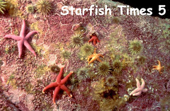
In the middle of the beach, at low tide, is a rock outcropping covered with kelp. The cove has a sandy bottom, which is usually covered with Sand Dollars. At high tide the rock is covered with water and draws a variety of fish. Most divers swim to the right side, where a rock reef juts out towards Ipswich Bay.
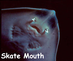
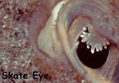
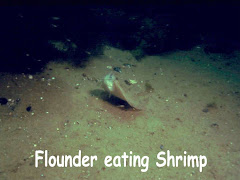
The kelpy rocks of the reef hide all kinds of tiny marine life, flounder and skates patrol the sandy central part of the cove. Local divers have found whale ribs and vertebrae here.
Ease of entry, and street lights for navigation, make this a great summer night dive. We've seen lot's of Squid, and the Lobsters come out to hunt (look but don't touch, you can't take Lobster at night).
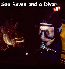
Day or night, it's possible to see Tautog, Cunner and Sea Ravens.
There's really nothing worth seeing any deeper than 30 feet, and reaching that depth puts you far enough into the bay to worry about boat traffic.
This is the place to go for your first dive of the season, or to introduce someone to New England diving. Entry is a snap, navigation simple (the cove funnels you right back), and it's a fun beach for those you're leaving behind.
LANES COVE
EXPOSURE: N
ENTRY: Rock, slippery at mid and low tides
DEPTH: 50 feet
DIRECTIONS: Route 128 to first rotary, 3/4 way around take 127 north. Pass Plum Cove and continue through village of Lanesville. Turn left just past convenience store, road descends to tiny harbor with granite breakwater. Best dive site is at the right end of that breakwater.
PARKING: There is a small gravel lot at the far right end of the breakwater. Don't block the private drive, or access to the boat ramp.
Lane's Cove is purported to be the smallest working harbor in the U.S. Named after John Lane, who fled Indian attacks in Maine to settle this area, the cove boasts some nice diving outside the breakwater.
Entry is across granite slab that is treacherous when wet, and for that reason this is not a good dive if there is surge. Heading straight out, you'll pass over kelp and lichen covered rocks. Don't pass too quickly, the rocks and holes are full of marine life. We once pulled a 3 foot Cod from a hole in shallow water, and gave him to some folks picnicking on the rocks.
As you go deeper, there are patches of bare granite, and open clearings of gravel. On several occasions we've seen large Goosefish and Sea Ravens in these spots. At 40 feet, the bottom drops off steeply (almost a wall in one spot) to the silt/sand at 50 feet.
During July and August, when the Dogfish (relatively harmless, but impressive, sand sharks) are in town... this is the place to see them. Sit at the bottom of the rocks and wait, they'll come.
You can venture out over the bottom... but why?
Turn back and head home, cheating a little to the left (east). There are great slabs of bare granite, and if you navigate well enough, you can end up just past Sunset Point, in a nice little cove with a few pretty outcroppings of Anemones.
There is often some current here, trying to take you up or down the coast. Rarely strong, it can wreak havoc with your navigation, so watch the bottom as you cruise for any sign the current is pulling sideways. Take care, or you'll end up in Folly Cove... great dive, but a long way from where you parked.
The combination of a difficult entry, and no significant shore lights make this a poor night dive. During the summer there are allot of lobster traps, so take care not to get caught in the trawl lines... and watch the boat traffic.
FOLLY COVE
EXPOSURE: NE
ENTRY: Rocky beach, slippery at mid and low tides
DEPTH: 50 feet
DIRECTIONS: Route 128 to first rotary, 3/4 way around take 127 north. Pass Plum Cove and continue through village of Lanesville. About 5.5 Miles from the Rotary is a pulloff above the cove.
PARKING: The pulloff is marked "Residents only" and often enforced. Side streets up and down 127 provide legal parking, drop gear and walk back
Ancient maps call this "Gallops Folly", after a Captain Gallop, trying to escape a storm, ran his ship up on the rocks. He thought he was entering Rockport Harbor, and is probably grateful that time has shortened the name to Folly Cove. Before his faux pas, the local name seems to have been "Blubber Hollow" so perhaps we owe Captain Gallop a vote of thanks.
One of New England's best known beach dives, it's extremely popular with photographers because of the sheer wall on the west side.
Entry is over a beach of weather rounded rocks, which can be very slippery when wet. Mid tide is particularly treacherous, if there's any surge at all.
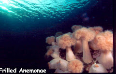
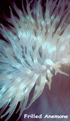
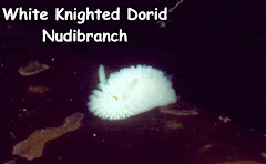
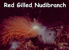
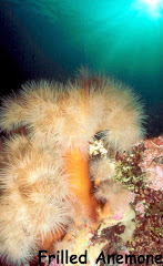
Once you're in, there is no wrong way to go. On the west is a wall, with tumbled down rocks, holes for marine life to hide in, and large quantities of Frilled Anemones in photogenic positions. There is a resident Tealia Anemone, hiding in a hole, that was fed regularly for years by a friend. Follow the wall all the way to the point, and you're in 50 feet of water. Bright red Sea Peaches, Stalked Tunicates and Nudibranchs grace the steep rocks.
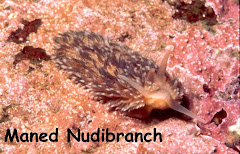
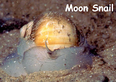
Come back in, and about halfway down the wall strike out along the sand bottom to the east. About the time you're bored with Sand Dollars, Skates, Flounder and Moon Snails, there will be a large outcropping of bare granite. Along with a few Anemones, there are often numerous Maned Nudibranchs, even in summer when they are otherwise rare.
Continuing to the eastern edge of the cove, you'll reach a kelp covered, rocky bottom that slopes down from the shore. There are plenty of holes, and this is a good place to see juvenile fish hiding. If you're far enough around the shore, you may stumble on one of the 2 huge old mooring rocks sunk there. The misguided owner of a local dive shop actually prefers the east side, claiming to have seen large quantities of Scarlet Psolus and other unpronounceable (but pretty) things.
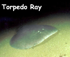
Depending on the season, this cove is home to a huge variety of life. Schools of Menhaden come within 5 feet of the beach, 6 foot (electric) Torpedo Rays have swum with divers in 8 feet of water, and tiny Cunner have bitten the lip of complacent photographers. Folly's not a great place for lobstering... because it's such a popular dive, the average combat life of a Lobster is about 30 seconds.
This is a prime night dive. The cove is funnel shaped, easing navigation, and there is a street light directly above the pulloff. Summer nights find squid flitting about in great quantity.
After a brief reminder about how tricky the rocks can be in a surge, there aren't really any other hazards here. Beware the boat traffic.... the site is so good private and charter boats do it as a boat dive. During the winter, a week or so of calm weather can result in 50+ feet of visibility.... and parking's allot easier to find.
HALIBUT POINT
EXPOSURE: N
ENTRY: Rocky, slippery when wet
DEPTH: 60 feet
DIRECTIONS: Route 128 to first rotary, 3/4 way around take 127 north. Pass Plum Cove and continue through the village of Lanesville. About 5.5 Miles from the Rotary is the pulloff above Folly Cove. continue for about 1/2 mile to LH fork at Old Farm Inn, brown sign announces "Halibut Point State Park"
PARKING: You can buy a day or season sticker that provides parking, and use of the park's facilities. From the parking lot to the sea is about 1/4 mile.
Halibut point marks the spot where Cape Ann juts farthest into the Atlantic. To the left is Ipswich Bay, with the shorelines of Massachusetts, N.H. and Maine on the horizon. On the right is the open Atlantic, and Sandy Bay.
Originally named "Haul About Point", because a fishing vessel that came too far past could get caught in the lee and becalmed, over the years it gradually shortened to the authentic sounding (if inaccurate) fish name.
This is one of those places where diving becomes an aerobic sport. It's a hike from the parking lot to the hard rock entry. Most folks make a day of it, doing two or three dives, squeezing as much pleasure as they can from one trek. The spot is stunningly beautiful, above and below. Eccentric literary giant Farley Davidson is often spotted there, on long contemplative walks, wearing a black fur coat (regardless of season).
The huge granite slabs at the shoreline continue on beneath the surface. Entry is tricky if it's surgy, and the rocks are wet. The huge sloping ledges drop steeply until they meet a sandy bottom at 60 feet. There are tumbled rocks, crevasses and crannies where marine life hides.
Calling this a northern exposure is a bit deceptive. Because it's a point, any substantial breeze from the North, East or West can create entry problems (take a peek before you tote in the gear). If the breeze is from the South... come on down.
Current rears it's ugly head from time to time, and boat traffic is substantial in summer. Night diving isn't feasible because the park closes at 8 PM.
This is not the spot for your Great Aunt Gertrude's first dive of summer. It is a great place to bring her when she's done a few easy ones, gotten a bit in shape. The underwater terrain is unsurpassed.
CATHEDRAL ROCKS
EXPOSURE: E
ENTRY: Rocky, slippery when wet
DEPTH: 70 feet
DIRECTIONS: Route 128 through 2 Rotaries to traffic light. Take a left at light and follow route 127 several miles through Rockport. Turn right at sign announcing "Ralph Waldo Emerson Inn". Cathedral Rocks and the sea are directly ahead of you.
PARKING: There is some parking, on the RH side only, right by the path that leads to the rocks. If it's full go back one block and park on a side street.
Since this is one of Cape Ann's most beautiful dives, it stands to reason that there's a price to be paid. From the road, you can see the rocky entry point clearly. Between you and the sea is a steep rocky descent, and you need to watch your footing.
Do it..... Unless you see surf massaging the rocks, this is going to be one of your favorite dives. If there IS surge... go somewhere else and leave this site to mountain goats
To your left, as you descend, is private property, including some rocks that extend all the way to the water. There's no need to stray there.
Entry is a bit tricky, over wet, slick granite. The tide level will determine where you put in... and you may choose to exit in a slightly different place.
The bottom drops off rapidly, starting as lichen and kelp covered rocks, and becoming giant granite blocks and slabs. The underwater terrain isn't much different than the granite above.... except it's full of life.
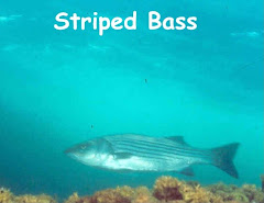
To the left is a broad cove, where many begin their dive. The cove, in summer, often has swirling schools of Menhaden, hiding Cod, occasional cruising Blues and Striped Bass.
Descending, in or out of the cove, the rocks are covered with patches of Pink Hearted Hydroids, colorful sponges and tunicates. The tumbled granite blocks provide nooks and crannies for all kinds of crawling things.
This is the place for the Northern Red Tealia. The area's most powerful anemone, this bright red and white beauty is capable of capturing whole fish. The bottom isn't covered with them... you'll have to look.... but there seem to be more here than anywhere else in the region.
For those who want to go deeper, you can reach 70 feet within reasonable swimming distance of the shore. At that depth, the bottom has become gravel and sand with patches of rocks.
A combination of interesting underwater terrain, and great variety of life makes Cathedral Rocks a very popular site. Don't make the mistake of trying, if there is surge.... it'll get you. Try another site, or watch your fellow divers look silly. Definitely not a good night dive... it's dark, and very difficult to find an exit.
Watch the boat traffic. Current isn't often a problem. If you dive winters, and the weather is right... you should come here. There are days when the visibility is so good, you expect to see palm trees when you surface.
Frilled Anemone
BACK BEACH
EXPOSURE: E
ENTRY: Sandy beach
DEPTH: 30 feet
DIRECTIONS: Route 128 through 2 Rotaries to traffic light. Take a left at light and follow route 127 several miles through Rockport. Pass 5 Corners, stay on 127 about 1/2 mile to Beach Street, turn right and you're there.
PARKING: Metered... cash or credit/debit card
A beautiful, family beach within walking distance of the shops and restaurants of Rockport. Entry is over sand, and is so easy it may trick you into thinking the dive's not worthwhile. This place even has Public Bathrooms (think what that can mean for your wetsuit)!
Since this is a popular spot, do your best not to intrude on other folks enjoying the beach. Representatives of the dive community and the town Selectmen have agreed on the sections most appropriate for divers to use for gearing up and entry. The posted suggestions don't have the force of law, but this collaboration is one of the big reasons for the recent improvement in relations between the two communities.
Swimming out, the bottom is a mix of sand and patches of rocks. Even a multitude of summertime bathers doesn't seem to faze a variety of little critters that hang out in the rock and kelp.
The dropoff is shallow, and swimming 100 yards will only put you in 30 feet of water... but it will bring you to a rock reef with Sea Ravens, and some Striped Bass.
Frolicking in the kelp, both in the shallows and on the reef, we've seen tiny Skeleton Shrimp, Pipe Fish and Decorator Crabs.
Rumor has it that the occasional Lobster has been dragged kicking and screaming from these waters. Anywhere on Cape Ann it's important to have a license, drag a flag, and make sure your Lobster is of age. This is downtown Rockport... so do all those things twice. It's not a great idea to flaunt your catch anywhere, but this is a special place not to do it. Local lobstermen work harder than we can imagine.... and some still think diving for the little critters is so easy, it's cheating.
Easy entry, good parking, street lights to navigate by..... a great night dive. Summer brings lot's of Squid in close. We've surfaced here at night, a hundred yards out or so, and rode the swell... looking at the lights, absorbing the peace and silence of it all...
This is a favorite spot of famed writer Rudy Davidson. Unusual among dive writers, Rudy does not swim, but he does enjoy strolling the beach, leaving little gifts for unsuspecting tourists.
Overtime parking tickets and distraction by tiny bathing suits seem to be the prime dangers of this spot.
OLD GARDEN BEACH
EXPOSURE: NNE
ENTRY: Sandy beach
DEPTH: 40 feet
DIRECTIONS: Route 128 through 2 Rotaries to traffic light. Take a left at light and follow route 127 several miles through Rockport. Angle at 5 Corners onto Broadway. At Broadway's end, turn right then take second left onto Norwood. Norwood will take you direct to Old Garden.
PARKING: Parking lot is Sticker Only. Drop gear off on the street and park on side streets. Old Garden Road is legal except weekends and holidays.
Drop your gear at the top of a nice concrete ramp, and go park about a block away in a beautiful neighborhood. Tote the stuff down the convenient ramp, across a rock, then sand beach.... elegant, civilized.
There are rocks to the left and right of the beach. Swimming out straight, or to the right, you'll find Volkswagen sized kelp covered rocks lying in the sand. During the summer Flounder and Striped Bass are plentiful.
Year round, Old Garden seems to be Cape Ann's nursery. Sit on the bottom next to one of the giant rocks, and watch carefully for a few minutes, and you'll likely spot something tiny hiding in the vegetation. You may look silly, but it's worth it. One local photographer lies so still she's been "rescued" twice.
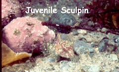
You may see juvenile Lumpfish, Sea Snails (a tiny fish), or Sculpin. During the Spring, colorful Nudibranchs lay their eggs in fragile veils, and year round Decorator Crabs play the clown by falling off the rocks when they're startled by you.
A good place to dive in the summer, it's great on a winter day. When conditions are right, the visibility is breathtaking, enough of the tiny life remains to keep it interesting, and you can admire the huge rocks.
This beach is right in the middle of a nice residential area, and good manners are especially appreciated. The "Divers Please..." guidelines posted on a sign don't have the force of law, but aren't intrusive. Night diving may be illegal here due to a quirk in local laws.
LOBLOLLY COVE
EXPOSURE: NE
ENTRY: Sandy beach
DEPTH: 20 to 30 feet
DIRECTIONS: Route 128 through 2 Rotaries to first traffic light, and take a left. Go approximately 1/4 mile, and take right at end of shopping center, then take LH at end of the road.. this is Route 127A. Follow this until Turks Head Inn, and take sharp (almost UTurn) RH onto South Street. Go to end, and take left on Penzance Rd. This brings you to Pebble Beach. Follow the road past Pebble Beach onto dirt road at the end.
PARKING: The dirt lot is Residents only, but you can drop gear there, and park at Pebble Beach.
Loblolly may not be as well known as some of Cape Ann's other sites. This is probably because of parking difficulties, since the dive has an easy entry, varied scenery, and substantial opportunity for obtaining a seafood dinner.
Gear up, and stagger gracefully over a sand beach (and a few rocks at low tide) into the shallow protected cove. The bottom is rocky, with alcoves that sometimes serve as home to Lobster.
The rocks are generally kelp covered, and the vegetation provides shelter, during parts of the year, to all kinds of tiny juvenile critters. Near the center of the cove is a rise that breaks the surface at low tide. Maximum depth in the cove is only 15 feet, making it a great place for a new diver, or your first dive of the year.
During the summer schools of Menhaden and Striped Bass enter the cove, during the winter this is a fine place to see Nudibranchs.
If you'll swim towards the cove's entrance, on the right, the terrain will begin to change. The southern approach to the cove is marked by a rocky outcropping variously called Loblolly Point, or Emerson Point. Going around the point, to seaward, the bottom becomes sloping granite, with attractive (to both divers and marine life) nooks and crevasses. The rock meets a gravel/sand bottom at about 30 feet.
PEBBLE BEACH
EXPOSURE: S
ENTRY: Cobblestone like beach
DEPTH: 20 to 30 feet
DIRECTIONS: Route 128 through 2 Rotaries to first traffic light, and take a left. Go approximately 1/4 mile, and take right at end of shopping center, then take LH at end of the road.. this is Route 127A. Follow this until Turks Head Inn, and take sharp (almost UTurn) RH onto South Street. Go to end, and take left on Penzance Rd. This brings you to Pebble Beach.
PARKING: Parking is legal on one side of the street.
Park legally within 100 feet of the water, enter over a beach of cobblestone rocks or sand (depending on tides) and snorkel south. About 75 yards out you'll spot the first of two rock reefs that parallel the shore. When you reach bottom (in 10 to 15 feet) the reef is a combination of kelp covered rock and patches of sand.
Swim up and down the reef awhile, looking for the animals that hide in the holes and kelp, then strike out south for the deeper (30') reef. While crossing the sand between the reefs, you'll pass over Flounder, Moon Snails, and Surf Clams hiding on (or in) the bottom. The second reef's terrain is similar, but the added depth often changes the variety of life on the rocks.
To the west end of Pebble, the two reefs come together, then rise into a rocky outcropping that shows above low tide. The seaward side is sloping granite, with long, deep crevasses. This area, and the beach to the west, is called Cape Hedge.
Winter visibility is often terrific in this area... but it's in Spring and Summer that this site has provided stunningly close contact with some of New England's more interesting fish. Early in the year Wolffish can be found in the rocks. These eel-like fish are reminiscent of Morays, with big teeth for crunching shellfish. Though they're shy (unless disturbed), a 4 footer will hold your attention.
During the Spring male Lumpfish guard batches of eggs. Shaped like a football, these fish can grow to 2 feet, and come in colors ranging from red to grey. Get between them and their eggs, and they may try to ram, buzzing you like a fat fighter plane. Not dangerous... but disconcerting if you don't expect it.
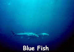
With Summer come Striped Bass and Blue Fish. Silver with black stripes, the Bass will come up to you in groups of 2 or more. Some divers feed them, and they seem not to fear humans. As large as 4 feet, dignified and graceful, these fish approach in water as shallow as 5 feet.
There are times when a gentle current will move up or down the coast, so unless you want to combine a walk on the beach with your dive, keep an eye out.
BASS ROCKS
EXPOSURE: SE and E
ENTRY: Rock
DEPTH: 15 to 35 feet
DIRECTIONS: Route 128 through 2 Rotaries to first traffic light, and take a left. Go Bass Rocks is the shore line on your left.
PARKING: Parking is legal on street except Saturday and Sunday. Weekends park on side streets (or stay in one of the nice motels along this stretch, and leave your car in front of your room).
This is a long stretch of rocky entry, with a variety of underwater terrain. All entries are over rock, and the most innocent looking of surge can make your exit painful... so if it's rough, go somewhere else. On the other hand.... on a calm day there are several places you can make a giant-stride entry.
The bottom, once away from the shoreline, varies from north to south. Rock meets flat sand on the northern end. During much of the year, this patch is covered with flounder... so many that divers sometimes surface to point the way for fishermen in boats. The zone where rock meets sand has been consistent home to large lobsters... one hole (in 8 feet of water) producing 2 twelve pounders in 2 weeks.
If you want your dive to be entirely over rocky bottom, enter the water south of the Bass Rocks Motor Inn. Tumbled rocks and notches give shelter to a variety of marine life. During the Spring big Wolffish seem to like the area, and Striped Bass cruise in close during Summer.
Bass Rocks has a reputation, among locals, as a place where the relatively few Lobster found.... are BIG. Some divers run regular routes, having found that large lobsters are often attracted to the same holes. (Compass bearings and distances available at exorbitant extra cost)
Boat traffic is often heavy here, and it bears repeating that even the smallest of surge can make exits dangerous.
Tealia Anemone

NILES BEACH
EXPOSURE: W
ENTRY: Sand
DEPTH: 15 to 20 feet
DIRECTIONS: Route 128 through 2 Rotaries to second light. continue straight onto what becomes E. Main Street. Niles is the only beach on E. Main.
PARKING: Legal parking right at beach (resident only in Summer).
Inside Gloucester Harbor, Niles is the beach of last resort... generally only used by folks who are determined to get in the water on a rotten day. Park right at the edge of the water, and waddle in over a sand/silt beach. Water clarity will sometimes be a pleasant surprise... if you don't stir things up.
A bit of redemption comes in the form of patches of grass in the shallows near the beach. Home to scores of tiny creatures, it's possible to find all sorts of juvenile things hiding in an attempt to become adults. Pipefish, tiny Flounder, Sculpin and Lumpfish hiding together. Swim out far enough and you will find some rocks with Sea Vase tunicates, and frequently... Nudibranchs. Adult Flounder cruise the silt.
Niles is used by Dive Classes on weekends when no other site is safe, and by other divers who've driven a long way and are determined to say they dove Cape Ann. It's included because sometimes you've got to get in the water... no matter what. This is the safest place to do it.
Across the Harbor is Stage Fort Park. It's on 127A, and the dive is about the same.... but there are nice facilities, so those you've left behind can have a better time than you.
WHITE'S BEACH
EXPOSURE: S
ENTRY: Sand
DEPTH: 15 to 25 feet
DIRECTIONS: Massachusetts route 127 south out of Gloucester through village of Magnolia. Turn left on Ocean Street and follow it past beach at Kettle Cove. Next beach is White's
PARKING: Resident stickers required to park right at the beach, drop gear and park on side streets.
When the wind is from the North or the West, Whites is an excellent choice. During the winter, when storms have reduced visibility on other parts of the Cape... Whites often boasts visibility in excess of 30 feet.
Off the center of the beach, the bottom is mostly sand, with only the occasional rock. If you'll go to either side of the beach, you'll find rock outcroppings with kelp, and grottos. During specific times of the Summer, Lobster migrate along the sand in herds. Catching them is less like a hunt.... than a cattle drive. Open your bag, and stampede them in. Doesn't happen often, but when it does.... Meanwhile, if you like, practice up for Lobster by catching the Flounder that are often laying about in the area.
If you've got a license, this is prime territory for digging Sea Clams out of the sandy bottom. From the tidal zone out to 15 feet, stick a blade almost anywhere in the sand and you'll hit a shell. They may not taste quite as good as Lobster and Flounder... but they'll rarely outrun you. Bring a big bag, a long knife, and strong wrists.
For the adventurous, Whites is within a reasonable swim of the wreck of the USS New Hampshire. Generally considered a boat dive, because of the distance, a number of folks do Scuba or snorkel from shore. One friend did it often enough that he developed a muscle. The wreck is snuggled next to the far side of Graves Island, off to the right. If you're determined... read the description in the BOAT DIVING section.

Cape Ann Boat Diving
BOAT DIVING
Surrounding Cape Ann are dozens, if not hundreds, of fine boat dives. Reefs, wrecks and walls are all found within a short boat ride of the local harbors. There are public boat ramps at Gloucester High School (close to drawbridge over the Annisquam), Rockport's Granite Wharf and in Lane's Cove at the breakwater.
There are several dive boats working the area, and any of the North Shore's dive shops can arrange charters to Cape Ann sites. Some boats operate year round.
The sites listed are a sampling of the terrific variety of boat dives found here. The sites listed are suitable for any competent sport diver, when conditions are good. There are challenging dives available to the more accomplished... wrecks, deeper walls. If you are interested in those, contact the local shops or charter operations for further information.
SANDY BAY BREAKWATER
LOCATION: 1 to 2 miles off Rockport
DEPTH: 70 feet
Sometimes called the Rockport Breakwater, this structure may represent the only time in history that the U.S. Government stopped a project because it was too expensive. The 1 1/2 mile granite breakwater was begun in the late 19th century to enclose Sandy Bay. Cape Ann would have had one of the largest harbors in North America. In 1902 the project halted for want of funds, and only 150 yards or so were completed. The rest approaches the surface, close enough to occasionally bite the bottom of careless boats.
Let the wind tell you which side to dive... both are great. Visibility can be markedly different from one side to the other, so, on a calm day, you may want to descend a bit on each. Choose the best and work on down as far as you find comfortable. The gravel and sand bottom is at 70 feet. Visibility is often very good, and tends to be a bit better to seaward (silt tends to settle on the land side).
Beneath the surface, the breakwater is a steep tumble of huge granite blocks. Dropped by barges, these rocks have formed tunnels, cliffs and caves... all sorts of beautiful angles covered with marine life. Large, unreachable, Lobsters torture you, Cod hide in holes and Lumpfish guard eggs.
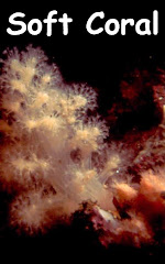
This is one of the few spots where you can get a good look at the whole range of life that clings to rock at various depths in New England. From Kelp and Hydroids near the surface, to beautiful (big) Frilled Anemone and sponges... finally reaching soft corals, Sea Peaches and Stalked Tunicates nearer the bottom.
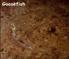
Summer brings Bluefish and Dogfish to the seaward side. Blues cruise the water column singly and in schools, while Dogfish put in frequent appearances on the bottom, along with the occasional Torpedo Ray and Goosefish.
A couple of things to watch for... lot's of boat traffic in the summers, and some current at times. The current is often tidal, Sandy Bay going over the wall in an effort to escape to the Atlantic, or vice versa. No real threat if you pay attention.
You'll look long and hard to find a better New England dive than this one. For scenery, marine life and variety... tough to beat.
THACHER'S ISLAND
LOCATION: Thacher's Island is about 3/4 miles east of Loblolly Cove on Cape Ann's east side. A short run from either Rockport or Gloucester Harbor.
DEPTH: 10 to 30 feet
During the early 1600's the Thacher family was heading to Cape Cod, when a storm drove their ship up on the rocks. Most of the crew, and all of the Thacher's children died in the wreck. As a token of sympathy, the Commonwealth of Massachusetts gave Reverend and Mrs. Thacher the island. A strange gift, and there's no record of the Thacher's ever returning.
The island is about 1/2 by 1/4 mile, and boasts two working lighthouses. For many years these twin lights were known as the "Eyes of Cape Ann". The lighthouse keepers were involved in a number of rescues, and the ramp from which they launched their boat still exists.
Depending on wind direction, any side of the island can provide excellent diving. Conditions permitting, try the northwest side, just north of the old boat ramp. You'll find crevasses, sloping ledge and some boulders. On this side, the rock meets a gravel bottom at 10 to 15 feet. The southeastern side drops off more abruptly, and to greater depths.
Come at the right time of the year, and you may find Thacher's surrounded by Lobster, Flounder and, in deeper water off the northeast side, Scallops.... sort of a seafood buffet.
During the summer many boats troll the area for Blues... watch out for both the boats and the fish.
DRY and LITTLE SALVAGES
LOCATION: About a half mile southeast of Sandy Bay Breakwater
DEPTH: 10 to 60 feet
Navigational charts reveal these 2 rock outcroppings to be part of the same underwater sea-mount (sea-foothill in this case). The Dry Salvages remain above the surface at high tide, while the Little does not.
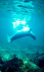
During Winter and Spring this is home to a number of Harbor Seals. Quite shy, they usually flop in the water when a boat approaches.
The granite continues beneath the surface pretty much as you see it above, sloping ledge with long trenches. You can reach 60 feet as you get farther from the rocks, but the real charm is shallow.
Long granite trenches start in shallow water, and form canyons as they descend. Their walls are covered with several varieties of colorful sponges, Blood Stars and Hydroids. With a bit of effort you can find walls with as much color and variety as a Caribbean reef.
Bluefish seem to hang around here in the summer, swimming above as you explore the canyons, and schools of Pollock sometimes startle you.
Very close in, and almost due north of Dry Salvages, is a formation of wide crevasses that is particularly special. The trenches run almost up to the surface, at the island.
To the Southeast is the wreck of the 64' dragger Racketeer. On a foggy day in June of 1994 her Captain full tilt boogied onto the rocks. She perched there until Labor Day when a storm dragged her sorry bones into deeper water. This is a typical New England wreck, twisted and torn, some parts recognizable, some junk.
This is a superb photographic dive, but current is sometimes a problem here.
Surrounding Cape Ann are dozens, if not hundreds, of fine boat dives. Reefs, wrecks and walls are all found within a short boat ride of the local harbors. There are public boat ramps at Gloucester High School (close to drawbridge over the Annisquam), Rockport's Granite Wharf and in Lane's Cove at the breakwater.
There are several dive boats working the area, and any of the North Shore's dive shops can arrange charters to Cape Ann sites. Some boats operate year round.
The sites listed are a sampling of the terrific variety of boat dives found here. The sites listed are suitable for any competent sport diver, when conditions are good. There are challenging dives available to the more accomplished... wrecks, deeper walls. If you are interested in those, contact the local shops or charter operations for further information.
SANDY BAY BREAKWATER
LOCATION: 1 to 2 miles off Rockport
DEPTH: 70 feet
Sometimes called the Rockport Breakwater, this structure may represent the only time in history that the U.S. Government stopped a project because it was too expensive. The 1 1/2 mile granite breakwater was begun in the late 19th century to enclose Sandy Bay. Cape Ann would have had one of the largest harbors in North America. In 1902 the project halted for want of funds, and only 150 yards or so were completed. The rest approaches the surface, close enough to occasionally bite the bottom of careless boats.
Let the wind tell you which side to dive... both are great. Visibility can be markedly different from one side to the other, so, on a calm day, you may want to descend a bit on each. Choose the best and work on down as far as you find comfortable. The gravel and sand bottom is at 70 feet. Visibility is often very good, and tends to be a bit better to seaward (silt tends to settle on the land side).
Beneath the surface, the breakwater is a steep tumble of huge granite blocks. Dropped by barges, these rocks have formed tunnels, cliffs and caves... all sorts of beautiful angles covered with marine life. Large, unreachable, Lobsters torture you, Cod hide in holes and Lumpfish guard eggs.
This is one of the few spots where you can get a good look at the whole range of life that clings to rock at various depths in New England. From Kelp and Hydroids near the surface, to beautiful (big) Frilled Anemone and sponges... finally reaching soft corals, Sea Peaches and Stalked Tunicates nearer the bottom.
Summer brings Bluefish and Dogfish to the seaward side. Blues cruise the water column singly and in schools, while Dogfish put in frequent appearances on the bottom, along with the occasional Torpedo Ray and Goosefish.
A couple of things to watch for... lot's of boat traffic in the summers, and some current at times. The current is often tidal, Sandy Bay going over the wall in an effort to escape to the Atlantic, or vice versa. No real threat if you pay attention.
You'll look long and hard to find a better New England dive than this one. For scenery, marine life and variety... tough to beat.
THACHER'S ISLAND
LOCATION: Thacher's Island is about 3/4 miles east of Loblolly Cove on Cape Ann's east side. A short run from either Rockport or Gloucester Harbor.
DEPTH: 10 to 30 feet
During the early 1600's the Thacher family was heading to Cape Cod, when a storm drove their ship up on the rocks. Most of the crew, and all of the Thacher's children died in the wreck. As a token of sympathy, the Commonwealth of Massachusetts gave Reverend and Mrs. Thacher the island. A strange gift, and there's no record of the Thacher's ever returning.
The island is about 1/2 by 1/4 mile, and boasts two working lighthouses. For many years these twin lights were known as the "Eyes of Cape Ann". The lighthouse keepers were involved in a number of rescues, and the ramp from which they launched their boat still exists.
Depending on wind direction, any side of the island can provide excellent diving. Conditions permitting, try the northwest side, just north of the old boat ramp. You'll find crevasses, sloping ledge and some boulders. On this side, the rock meets a gravel bottom at 10 to 15 feet. The southeastern side drops off more abruptly, and to greater depths.
Come at the right time of the year, and you may find Thacher's surrounded by Lobster, Flounder and, in deeper water off the northeast side, Scallops.... sort of a seafood buffet.
During the summer many boats troll the area for Blues... watch out for both the boats and the fish.
DRY and LITTLE SALVAGES
LOCATION: About a half mile southeast of Sandy Bay Breakwater
DEPTH: 10 to 60 feet
Navigational charts reveal these 2 rock outcroppings to be part of the same underwater sea-mount (sea-foothill in this case). The Dry Salvages remain above the surface at high tide, while the Little does not.
During Winter and Spring this is home to a number of Harbor Seals. Quite shy, they usually flop in the water when a boat approaches.
The granite continues beneath the surface pretty much as you see it above, sloping ledge with long trenches. You can reach 60 feet as you get farther from the rocks, but the real charm is shallow.
Long granite trenches start in shallow water, and form canyons as they descend. Their walls are covered with several varieties of colorful sponges, Blood Stars and Hydroids. With a bit of effort you can find walls with as much color and variety as a Caribbean reef.
Bluefish seem to hang around here in the summer, swimming above as you explore the canyons, and schools of Pollock sometimes startle you.
Very close in, and almost due north of Dry Salvages, is a formation of wide crevasses that is particularly special. The trenches run almost up to the surface, at the island.
To the Southeast is the wreck of the 64' dragger Racketeer. On a foggy day in June of 1994 her Captain full tilt boogied onto the rocks. She perched there until Labor Day when a storm dragged her sorry bones into deeper water. This is a typical New England wreck, twisted and torn, some parts recognizable, some junk.
This is a superb photographic dive, but current is sometimes a problem here.
Harbor Seal
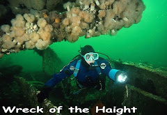
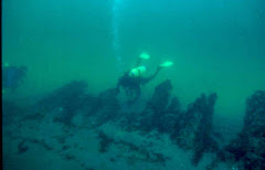
The Wreck of the CHELSEA
LOCATION: The bow of the small coastal tanker Chelsea is about1/2 mile NNE of Thacher's Island. The wreck is depicted on marine charts for the area.
DEPTH: 40 to 50 feet
One of the careless vessels referred to in the section on the Sandy Bay Breakwater is... you guessed it.. the Chelsea. The small coastal tanker, ugly when she was built in 1919, remained so until she hit a submerged section of the breakwater in February of 1957. She sank while under tow by the Coast Guard, and has become a beautiful wreck.
Resting on a rocky bottom at 50 feet, the bow is the only intact section. The prow sits upright, and looks like a wreck should. A companionway still leads to belowdecks, but you can swim in through the fractured hull. The stern has been reduced to a pile of rubble more typical of most New England wrecks.
A ledge has apparently protected the bow, which poses beautifully next to the kelp and rock outcropping. The hulk is encrusted with anemone and hydroids, with fish often cruising above, and inside.
This is a nice wreck, with an exciting story. The Coast Guard cutter's crew almost didn't cut the cable in time when she began taking on water while under tow. It was a near thing, but the tankers crew of six all survived... as did their rescuers.
There is some current here from time to time... and it can come up quickly during the course of a dive. This is a fun, and safe, site (but make sure the boat captain watches the current).
BRACE COVE and BRACE ROCK
LOCATION: About a half mile east of Dog Bar Breakwater (Eastern Point)
DEPTH: 10 to 20 feet
Take the main channel out of Gloucester Harbor, turn left at the lighthouse, then hook your first left into Brace Cove. Stop any old place, and drop the hook.
Brace is a sheltered, picturesque cove surrounded by rocky shoreline. The bottom is sand and weather rounded rocks, and is usually visible from the surface.
This is an ideal place to take snorkelers, or divers who are going to practice new skills like photography. Visibility is often excellent, the terrain interesting... and it's a place where keeping track of a buddy is fairly easy.
The big round rocks are scrubbed clean, the sand is white.. a cheerful place to dive on a sunny day. Flounder sometimes sun themselves on the bottom, and schools of baitfish flit around. Lobster seem to be in every cranny... and they're all shorts.
Snorkelers or the folks on the boat can watch as you try and catch dinner, or just fool around. This is "McDive"... reasonable quality, with minimal trouble.
At the cove's entrance (on the right) a giant rock juts above the surface. Cleverly named Brace Rock, it represents an entirely different type of terrain. Swim around the rock to seaward and you'll find kelpy walls, anemone and deeper water (and sometimes legal Lobster). During the summer Striped Bass whip in and around the rocks.
If you go far enough around the bend, and hug the shore (that does sound "around the bend") you may bump into what's left of a trawler named the Ohio. All that remains of her unfortunate contact with the rocks is a bit of hull, a diesel engine and some deck gear.
Brace is a boat dive because all of the surrounding shoreline is private. The only serious danger here is hitting the rocks lurking near the entrance as you pull in. Take care the channel is narrow at low tide.
This is an ideal spot to finish a day of diving, or a warmup at the beginning of the season.
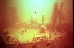
Wreck of USS New Hampshire
GRAVES ISLAND and the Wreck of the USS NEW HAMPSHIRE
LOCATION: Just off Manchester MA, 3 1/2 miles down the coast from Gloucester Harbor. Wreck is on the SW corner of Graves Island, between Graves beach and White's Beach
DEPTH: 20 to 25 feet
Holed for 104 guns, the Alabama was one of the largest wind powered warships ever built for the U.S. Navy. The hull was laid down in 1819, and her metal fasteners were made in Paul Revere's shop.
Since there was no war on the horizon... the hull was mothballed for future use. The onset of the Civil War brought her employment and a new name. Since Alabama was the enemy, she was renamed the New Hampshire and after 45 years on the blocks, launched in 1864. She was part of the blockade force off South Carolina, and eventually became a training ship.
In 1921, a motorboat's backfire set an oil slick ablaze... and she burned and sank at her dock on the Hudson River (the dock and office building burned too.. but did not sink).
A salvage company raised her, and took the hulk under tow for Eastport Maine, where they were going to break her up and sell salvageable materials for an estimated $70,000. While passing Manchester, Massachusetts smoke was seen pouring from the bow, and the tug picked up two men who'd been riding her. All watched helplessly as the last American Ship of the Line drifted on to Graves Island and burned to the waterline.
Raids by the locals, 3 efforts by salvage companies and seventy years of storms have reduced the wreck to ribs and planks jutting from the sand bottom off Graves Island's southwest coast. The wreck is never the same twice... wave action and storms cover and uncover new pieces constantly. For 30 years divers have recovered copper spikes and drift pins, and cruised this little piece of history. The constant changes in the bottom continue to bring artifacts within reach, and you've got a fine chance of finding, and bringing home, a hunk of history.
Some folks make the swim from Whites beach... it's a long one, but the best way to dive the New Hampshire is by boat.
EGG ROCKS (GREAT EGG and LITTLE EGG)
LOCATION: Just off Manchester MA, 2 1/2 miles SW of Gloucester Harbor
DEPTH: 10 to 50 feet
These two rocks, about a quarter mile apart, jut above the surface off Cape Ann's coast near Manchester. The dives are so similar in nature that supremely competent divers (like us?) have
become a bit confused about where we actually dove on a given day. After carefully consulting the
charts we discovered our dive was not where we thought it was. It was definitely not Egg Rock. To this day our name for Little Egg Rock is "Not Egg Rock".
The most interesting diving, at both locations, is on the seaward side. The rock is kelp and mussel covered near the surface, then drops off steeply to 40 to 50 feet. The drop-offs have crevasses and overhangs with colonies of anemone and bright hydroids. Granite outcroppings are encrusted with colorful sponges. Lobster frequent holes, and there seem to be allot of Lumpfish in early spring. Ocean Pout are sometimes found on the gravel bottom.
Lumping these dives together like two McDonalds franchises probably does them injustice. Perhaps you should think of them as identical... and beautiful (handsome, if you prefer) twins. Great Egg is bigger (surprise) and has some nice overhangs on the southwest side. The truth is, if you make the same mistake we did... you'll still have a nice time.
Watch for a sporadic current paralleling the shore, and boat traffic. The current can be strong, and on one occasion we had need of the boat traffic to return an errant diver.
PADDOCK ROCK
LOCATION: Seaward of the two Egg Rocks
DEPTH: 15 to 90
At first we thought this was a coffee spot on the chart... but it had a name, so one cold winter day we dropped over the side to see what was down there. The map indicated a shallow spot surrounded by deep water, and so it seemed.
Bare granite, not unlike the nearby Egg Rocks, sloping down to about 30 feet, and then... an absolutely vertical drop to 85 feet. The wall is covered with all sorts and colors of tunicates, hydroids, and anemone. Descending, you'll find a matching wall about twenty feet away, the two forming a ravine made by God's own trenching machine. The bottom is sand, with all sorts of fish fooling around in the shelter of the rocks.
Paddock Rock shows clearly on the charts, but unless you have superior navigational skills, you'll want to do this one off one of the charter boats with local knowledge. Once you're close, the top of the sea-mount can often be seen. Because this site is a bit farther offshore than others, it often boasts fine visibility.
KETTLE ISLAND
LOCATION: Just off Kettle Cove, Magnolia MA, about 3/4 miles SW of Gloucester Harbor.
DEPTH: 10 to 20
Kettle Cove dents the coast of Cape Ann just to the west of Norman's Woe, and provides mooring for a number of pleasure boats. Just off the mouth of this natural harbor is Kettle Island.
Norman's Woe is famous for the "Wreck of the Hesperus", which never happened, and Kettle Island is named not for a pot, but more likely for John Kettle, an early settler. The name appears as early as 1634, but there is no record of anything exciting ever happening here.... at least until now.
The gravel and sand bottom of the cove reaches across the channel from the mainland, and butts abruptly into the rocky side of Kettle Island. The island's shoreline rises from the sand in a tumble of kelp covered rocks. On the landward side, the rise is somewhat gradual, with cubbyholes and hiding spots for you-know -who (gets red after steam bath). Flounder and Sea Clams are on (or in) the sand.
The bottom drops off more steeply on the seaward side, to gravel and rock. The rocks are bigger, and the terrain more interesting.
During the Spring and early Summer, you might try a quick dip in Kettle Cove. When the Lobster are moving, they've been known to march across the bottom in near military precision. It's a rare sight... but worth taking a peek.
Boat traffic can be a significant danger on 3 of 4 sides of this island. Stay close to your flag. The north and south sides are on the boat route from Beverly to Cape Ann, and boats come close to the east side as they enter Kettle Cove. Some are moving at a fast clip, in a tight area (we've met the enemy... and he is us).
Tanker "Chester Poling"
The Wreck of the Chester Poling
LOCATION: About 1500 yards S.E. of the Dog Bar Breakwater
DEPTH: 80 feet to the deck, 100 to bottom
In January of 1977, the Chester Poling was an aging 281' coastal tanker when she set out from an oil terminal near Boston heading towards Newington, New Hampshire.
The predicted 15 foot waves, and 30 knot winds didn't trouble her Master, but the 30 foot waves and 65 knot winds that developed DID.
Captain Burgess ordered a turn to port, attempting to reach shelter behind Gloucester's Dog Bar breakwater. Moments later he heard a crack... then another, and cleverly noted that the rest of his ship was no longer behind him. Alertly sensing danger, (the stern was now broken off and NEXT to the bow), he radioed a MAYDAY that set in motion a heroic rescue effort by Gloucester Coast Guard, the crew of the pilot boat Can-Do and a helicopter. All but one of the crew were saved, and the ship sank in 2 sections. The bow is upside down in water too deep for a sport diver. On the other hand, 165' of the stern rests upright, and intact in 100' only 1,500 yards off the mouth of the harbor.
Homely beyond words during her career as a tanker, like the ugly duckling, she's grown beautiful with age. Most of her deck gear is covered with anemone, tunicates and soft coral. During the summer huge schools of fish circle above her. The single lifeboat davit stands covered with anemone, on the stern superstructure, flashing bright colors whenever a divers light strikes it
For an experienced diver it's reasonably safe to penetrate all the way to the engine room, and lots of hardware remains. Two moorings are fastened to the hull, and make finding and anchoring on the wreck easy. When the weather is good the dive is challenging, but not dangerous. There are some excellent shallow sites nearby for a second dive.
It adds an extra dimension while diving here to imagine the courage of the boat and copter crews who performed the rescue at this spot.. in 30 foot seas. The crew of Can-Do was killed a year later in another rescue attempt.